In the desert, they can’t remember your name cause there ain’t no one for to give you no pain. -America

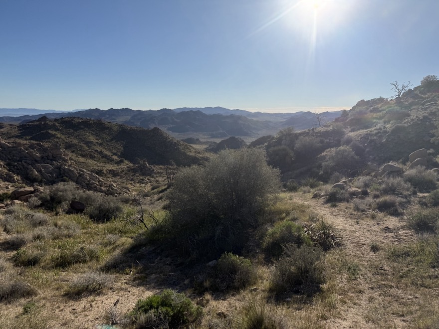
Three of the past four years I’ve returned to Joshua Tree in the winter for a soul searching backpack trip. Yes, this is a cliche, but with the hustle and bustle of the holiday season, this trip becomes a personal trip for me, where I can reset, clear out the cobwebs and enjoy being alone for a few days.. In my search for solitude, Joshua Tree is the one place I can almost guarantee I will acheive my goal. This trip would prove to be no different. This trip would also prove to be somewhat of a mental cleanse for me. There are major changes on my horizon and I’ve been struggling to process exactly how I fit into those changes (more to come on this topic).
I’ve been eyeballing a trip on the western edge of Joshua Tree that would involve a decent amount of cross country. The route I planned was to be 36 miles over 3 days, 2 nights. When my trip was overwith, I actually walked 40 miles (according to CalTopo).
I set off from the central coast of California in the late morning. I arrived in Yucca Valley around 3pm, and needed to drop off water cache’s at two different spots. Due to the extreme price of gas, I drove my commuter car, a Prius. This may have been a mistake, because driving that Prius on desert dirt roads proved to be a challenge in itself. Even worse, my new Ford Bronco with 35′ tires was sitting in my driveway at home collecting dust. I arrived at Upper Covington Flat trailhead around 3:30pm, and ditched 2 gallons of water in hard plastic containers. I marked the spot with a waypoint, hid them the best I could, and got back in the car and hurried to the west entrance of Joshua Tree, losing daylight with each passing minute. I hurried over to Quail Springs campground, hiked down trail about a mile with two more gallons of water in a backpack and found a nice area to stash them, right near the entrance to the Johnny Lang connector trail. As I walked back to the car, I was treated to an amazing sunset that only Joshua Tree can deliver. I left the park, placed an order at the Joshua Tree Saloon, picked up dinner, headed to my hotel (The High Desert Inn is only $85 and was relavtively comfortable and close to everything), ate dinner and was finally able to relax and get a good night sleep.

The alarm was set for 6am. I was up earlier than that. I took one last shower, finished packing my gear and headed to the Roadrunner Cafe to pick up a quick breakdfast of a veggie tofu breakfast burrito, coffee (a couple bags of Joshua Tree Expresso for home), and a premade sandwich for lunch on the trail. By the time I got to Black Rock Campground, the start of my trek, the coffee and burrito were done and I was ready to roll…
My backpack weighed in at 22.4 pounds. I was carrying a 1.5 liter smart water bottle full of water, another empty one, and a full 16 oz. water bottle for a bidet (and in a pinch, extra water). This should get me to my water cache, where I would load up the 2 gallons for the next 24 hours.
I headed up the California Riding and Hiking Trail (CRHT). The first 4-5 miles are up a sandy wash, and a lot of the time you feel like you are walking on an uphill beach. I was a little worried about coming back out on the last day, as I was going to take the Bigfoot trail which would drop me off on the CRHT, but reports were the trail was unmaintained and not marked. This was true, but I was able to find where it connected, and as I walked up that trail a little bit, I could make out a track of trail and it seemed easy enough. I continued to the top and soon was on hard singletrack. I love his part of trail, as I’m now in the higher elevations and the Joshua Tree’s grow a lot bigger out here. After 3 or so miles of pleasant hiking, it was now around noon, and I had made it to my water cache. The water was exactly where it was supposed to be. I sat under the shade of a Joshua Tree and ate my sandwich I packed in (Roadrunner Cafe gets two thumbs up from me). I filled up both water bottles as well as my 6 liter MSR Dromedary Bag with the clear cold water, threw them in my backpack, and instantly, my 22 pound pack was now about 40 pounds… UGH….. My goal for the first night was Juniper Flat, which was still about 5 – 6 miles away and featured a climb, long decent and then regain the altitude from that decent. It was going to be a long afternoon. The other problem? It is dark at 5pm. So basically, I had about 4 hours to make things happen….


Immediately I could feel the massive difference in weight on my shoulders and back and it was bothering me. So what do I do when this happens? I pull out the magic air pods and put on a killer mix of backpacking music. Soon enough, I was back in rythym and making miles. My next goal was the top of a ridge some refer too as “Tortilla Ridge,” because on a clear day, you can see the Salton See and all the way south into Mexico. Once I passed the ridge, I dropped down, past a spot I camped at a few years ago, and kept going. I continued to drop in elevation where I comtemplated camping, but knowing I had about an hour and a half of daylight left, I pushed on, turning up the music. I was gaining elevation, inspired by Tom Petty, Pearl Jam, and Johnny Cash. I gained the ridge and right in front of me was an amazingly flast spot, perfect for my tent. There was a rock outcrop right next to my tent where I could sit, watch sunset, eat dinner, and relax. I checked my map. I was only a half mile of flat walking to Juniper Flat. No way any campsite there would be as great as this one, so this was home. I dropped my pack, setup camp quickly, and while sunset happened, I enjoyed a backcountry tortilla pepperoni pizza.

All told, I hiked 13.55 miles, climbed 2391 feet and set myself up nicely for day 2. I climbed into my tent around 6:30pm and watched a movie on my phone until I fell asleep. I was woken up by my tent violently shaking around 10pm. Startled, but quickly realizing the wind gusts were shaking me all over the place. I laid in bed and tried to ignore it, but failed. I think I finally fell asleep around midnight.

Day 2 was a godsend. I woke up to a bluebird morning. The sky was magnificently blue and there was not a cloud to be seen anywhere. I saw a backpacker walking past my camp. We said a quick hello and he was off. This would be the first sign of human life in 24 hours. It was oddly satisfying. After a breakfast of Ramen and coffee, I quickly packed up and headed up trail. The next 3-4 miles were otherworldly. After the day before of constant climbing and descending, these trails were as flat as can be. I doubt I gained more than 20′ of elevation for over an hour.


Eventually, I rounded a corner and could now look down upon the main part of Joshua Tree. The Wonderland of Rocks was as imposing as ever. I could make out a car or two from their reflections. I knew I needed to go off trail and start working my way towards the Wonderland of Rocks. I had about 4 miles of cross country to get to the road, where I would then walk north to my next water drop. I stepped off trail, and started walking in a northeast direction, losing altitude and stepping in countless holes I could only assume were the homes of desert creatures. Although I’m not bothered by many animals, I am deathly afraid of tarantula’s or any other spider with 8 legs. So each time I sank into a hole, my heart skipped a beat, and I quickly moved on.
Joshua Tree is full of surprises. Today was another example. After about 2 miles of cross country, I stumbled upon a dirt road. This road was not on my CalTopo map, my national geographic map, or my Tom Harrison Map. The road proceeded northbound, so because it was going in the general direciton as where I was headed, I took the road. I eventually turned off to make sure I was continuing northeast, when I looked into the distance and saw what appeared to be a building. Once again, I made it back to the road and walked up to an old ranch in disrepair. There was a few buildings, sheds, a main house, and an old rusted car. The sign on the front of the ranch said, “May It Never Crumble, Randolph Ranch, J.T.” I love this type of stuff. I’m a total sucker for California History. I spent a few minutes here, appreciating the ingenuity of the habitants of this desolate environment.


I proceded on, where I picked up a wash going northbound. I took that a few miles past Lost Horse Ranger Station (closed), and continued on, alone, and happy. Around 12:30 I made it to the Johnny Lang Connector Trail, quickly found my next two gallons of water and took a break for lunch. Lunch was a tortilla with salami and cheddar cheese, some Dill Rice Cakes and a few flavored almonds. I had a cell signal, so I was able to call my wife and check in. I always get a sense of peace talking to her when I’m on trail. She knows me, knows how I am, and lets me geek out, telling her about all the cool things I’m seeing and experiencing. Feeling refreshed, I packed up my now 17 pounds heavier backpack, and was back on trail.
I headed northwest on Quail Wash Historical Trail. Now I’m not sure what the historical value of this trail is. I suspect it was a road a long time ago, but in present day, it is a ten foot wide sandy wash that feels like you are walking on the beach. Once you pass Samuelsons Rock (which is a worthy destination in itself to see the history), the trail kind of breaks up and you are literally walking in an overgrown dried river bed.

Thankfully, the rangers chose to put up signs with arrows periodically to keep you on track. These helped. It was now late afternoon, and despite the prolonged periods of beach walking, I felt good. I sat down at one point to take a break. The only sign of anything alive the entire day was a desert hare with huge ears that reminded me of my German Sheperd when he was a pup. It was fascinating to watch him run and bounch with lightning speed away from me. I tried to get my phone out to take a picture but it was already gone. I realized at some point I missed a trail reroute, which would have put me on a one mile stretch of singletrack to avoid the wash, but I knew I was headed in the right direction so I kept going. This was probably a mistake, because I was walking and getting poked by some of the thorniest bushes ever. I was bleeding all over my legs, and as a result, I spent an inordinate amount of time criss crossing the wash trying to find the path of least resistance. Finally, I saw the missed trail dump back into the wash, and it opened up. My legs thank you. I was now over 14 miles in and searching for the Bigfoot Connector Trail. This trail would take me up out of the wash, due west, and eventually connect with the CRHT. My goal was to camp at the beginning of Bigfoot. After a few more minutes of hiking I could see the trail heading up the hill. I still felt good, so I began climbing to mitigate some of the climbing I would have to do tomorrow. I know I’m done when without thinking about it, I’m looking for a camp spot. And today was no exception. Lucikly, I found a magnificently flat spot, near a rock outcropping where I could view the entire Quail Wash trail I had just hiked as well as in unimpeded view to the east and to the mountains I would climb the next morning to the west. I pitched my tent, got camp chores squared away and enjoyed a dinner of noodles, Aidelle’s Andouille sausage and red pasta sauce while sitting on a rock outcropping watching the sun go down in the west. Besides that one hiker I saw to start my day, I saw no one else. It was completely silent and I was completely alone in my own world. It was wonderful.

I cleaned up, climbed into my tent and began watching a series I downloaded off Netflix, Wyat Earp and The Cowboy War. Soon enough, I was asleep. It was perfectly silent and not a hint of wind. Perfection.

I never sleep very well the night before I know I’m hiking out. I think it’s the nerves and being anxious to get on trail, especially when I know I have a big drive ahead of me. My alarm was set for 6am, but I woke up at 5:45. In fact, the inside of my tent was packed before the 6am alarm went off. I packed my gear, drank a big swig of water, and actually poured some leftover water out. I guarantee I made some plants day. I packed a bag of beef jerky and a jolly rancher on my hip belt pocket. That should get me to the finish line. I had roughly 9 miles to go. Basically 4 miles up, 2 miles flat, 3 miles down. This is the time I start thinking about real food. I’ve trained myself to not think about “real” food on a trip. That just makes you want to end your trip soon to satisfy the cravings. Frankly, that’s a weak excuse to leave the places we go early. But now it was all about Josha Tree Saloon. Or maybe Del Taco? Or both?!?!

I started the climb. It was a long steady gradual climb. Not steep, but unrelenting. The past few months I’ve really focused on my fitness, nutrition, and hydration. This trip was a test. So far I passed with flying colors and was very happy with where i am at. Today proved to be no different. Eventually, I climbed thru a small pass and was surrounded by a mountain amphitheater that had mountains 500′ all around me. Because of the high grass and sage, I could not tell where the trail went up until basically, I was staring at a trail that went straight up into switchbacks.

These switchbacks were steep. There were only 6 or so of them, but after 4, I was already 100′ above the trail. As I slowly climbed, up, I turned a corner and was shocked to see 2 people coming down the trail. We greeted each other and I learned they were locals, living in Yucca Valley. This was their favorite trail for the views it afforded, but more importantly, for the isolation and lack of tourists. He told me I was the first person they had ever seen on this trail, and they were shocked that I was backpacking and going UP the trail! Great….. Soon enough we said our good bys, and the woman said, “good luck!” I still dont know how to take that. But again, my fitness was strong, and looking back on it, I think those switchbacks were the worst part of the trail. I eventually topped out and I could see down on Yucca Valley and beyond,. The view was stunning.

I started on rolling hills, going behind mountain tops, then going over them. I made good time in this stretch as my climbing was mostly done and I was taking advantage of downhill and flat ground. I turned a corner, went over a little pass and there it was, Covington Flat Road. I was in familiar territory.

I crossed the road, but I could not pick up the trail. It was a neverending sea of sage, juniper, yucca, and other desert plants. I pulled out my compass and noted that if I proceded in a northwest fashion, I should intersect the trail. I looked out into the distance and saw a lone Joshua Tree. That became my landmark.

Within ten minutes I stumbled onto the trail, hidden by the tall grass!

I made good time, covering the flat terrain, and within thirty minutes intersected the CRHT, right where I saw it three days ago. The home stretch! It was three sandy miles down to my car. Soon enough I could make out Black Rock Campground, some tents, and a car or two. And just like that, I turned the corner and could see the trailhead sign, and numerous people on horseback and two backpackers. I stopped to talk to the woman with the backpack. She had a lot of questions. I told her about some great campsites I was aware of that would be just enough for one or two tents. She laughted and told me to turn around. When I did I saw atleast 20 teenage kids with backpacks on. She was leading an outdoor education class for two nights. It would be pandemonium wherever they chose to camp! Thank god I was done!!!!

I got to the road and there was my car. In that car was a liter of clean water and a change of clothes! I looked around, and when I was confident I was by myself, got naked in the parking lot and put on some clean clothes! Damn that’s a good feeling! It was 11:30am. I needed to be home at a reasonable time as I had to work tomorrow morning early (7:30am). I hit the drive thru of Del Taco, ordered up way too much food and started the drive home. This trip was a success in so many ways. I needed this trip to clear my mind. I am retiring from my job in two weeks. I am ready, but I am nervous. This trip helped me be comfortable with my decision. The quiet and solitude forced me to dive deep into my head, and I did. There times I was emotional. There were times I was happy. I found myself crying happy tears while walking in a wash, and there were numerous times I got choked up with fear and frightened tears. But looking back on it, this was exactly what I needed to get grounded for the second part of my life.
I drove the 8 hours home in complete silence. No music. No radio. Complete silence. And the 8 hours went by like that….
I am a mountain man at heart, but there will always be a big of desert rat in me. Just keep those tarantula’s in their dens. Until next time Joshua Tree!